
Tongariro Alpine Crossing, the big daddy of day hikes in New Zealand. Remember that nasty glow on the horizon Frodo and Sam spent two films reaching? And those barren lands of Mordor you see in the third? Well this hike takes you through the very same place. And whilst the real-life version isn’t quite glowing, its sulphuric vents and craters steam, and Mt Doom (Mt Ngauruhoe) is very much active. Can it get any more epic in one day? I don’t think so…
This hike takes you through some of the most spectacular and alien landscapes you could hope to see as a casual hiker. If you’re looking for bang for your hiking buck, it really is a winner. But at 19.4km long and taking on average 7hrs, it’s a challenge not to be taken lightly. Don’t worry, though – this Tongariro Alpine Crossing guide has got you covered:
Out on the hike
How to get there
What to bring
How hard is the Tongariro Alpine Crossing?
OUT ON THE HIKE: Mangatepopo (1120m) to Ketetahi (760m)
I drifted in and out of sleep as the bus traced the edges of Lake Taupo. It was still too dark to tell if the skies were clear. The next time I looked out the first rays of sun were hitting the top of Mt Ruapehu. I could not wait to get stuck into this hike.

We were dropped at a little car park and shelter at Mangatepopo. There were a lot of people and other buses around; it’s the busiest I’ve done in New Zealand by far. It’s nothing to worry about, though; after the first hour or so everyone spreads out into tiny dots in this vast landscape.

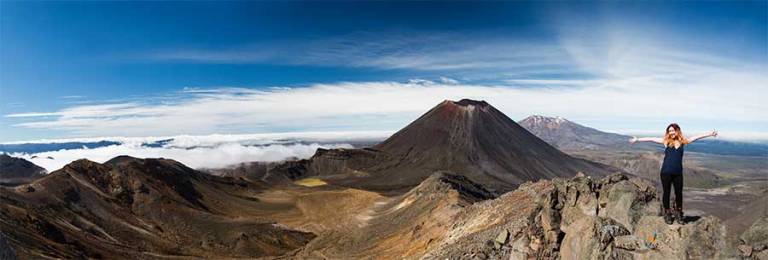
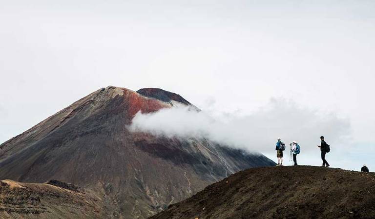
The hike starts gently and the landscape is nothing to write home about yet, apart from the unmistakable cone of Mt Ngauruhoe looming in the distance, reminding you that you’re very much in volcano territory now. But as the ascent gets steeper things start to get better. The vegetation whittles away and the views become more panoramic, stretching for miles across the park.
After just two hours I found myself at the base of Mt Ngauruhoe. It’s a monstrous beauty, both enticing and intimidating. Here the path splits; you can either go up it (2287m with no path and all scree – loose pumice) or carry on down the main track. A short while later there’s another side track up to the summit of Mt Tongariro (1967m with a track). I had been told by the bus company that it was impossible to do both summits – for the average person, at least.

It was a tough decision for me, but I decided to go to Mt Tongariro; I thought I’d get the best views of the infamous Mt Doom this way. It was a bit of a scramble at times, adding a good 2 hours onto my hike (including the hundreds of photos I took). And damn was it awesome.

I do regret not going to the top of Mt Ngauruhoe, though; I had a residual feeling of defeat about it.
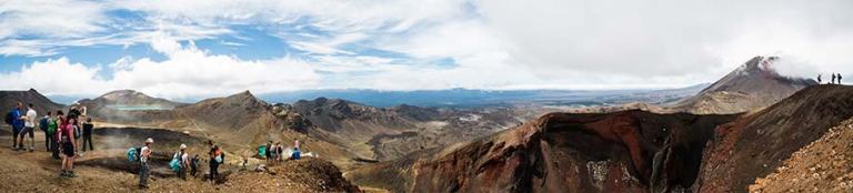
But no matter what route you choose, you will find yourself walking through epic alien/Mordor territory. It’s a huge desolate area. The hikers are dwarfed by the landscape so much that you can’t even see them in my photos, but if you zoom in close enough you’ll see that they are in almost every image.
Not long after the Mt Tongariro side track I found myself here:

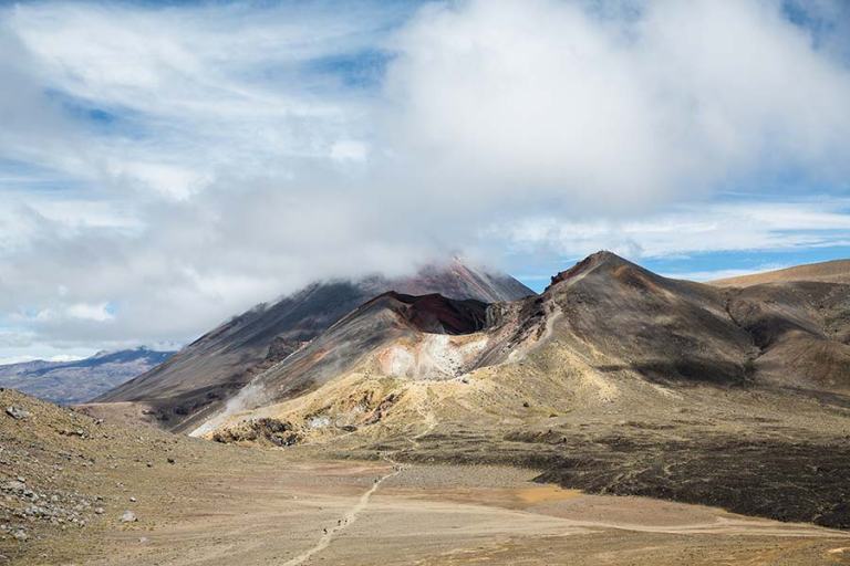
Perched 1886m high on the edge of a volcanic crater complete with eggy smells and bellowing steam. It’s the most stunning part of the main track for sure.
Next comes my favourite part of the hike; a steep descent down its side. It’s all scree at this point. A lovely kiwi lady, middle-aged and built like an ox, showed me the trick to getting down: face sideways, dig your boots in deep and slide down. You barely even need to lift your feet and speed is no bad thing. The worst way is to tiptoe down.
Tearing down the scree I had to keep on reminding myself of what I was doing; I am sliding down an active volcano. Yes, the very edge of an active volcano.

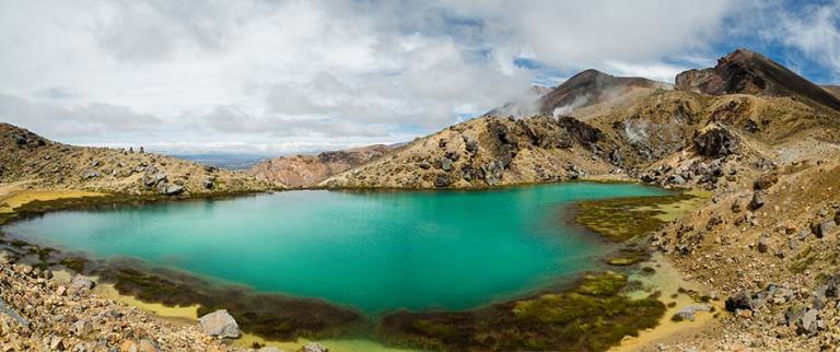
Now you’ll reach those amazing coloured lakes. It’s easy to forget how big the landscape is here – they take a deceptively long time to pass, even though the land is flat.


Don’t forget to turn around to get a wider view of what you’ve just slid down:
Blue Lake, 6 hours into the hike (Mt Tongariro included), marks the end of hardcore Mordor territory (though it’s still an active volcanic hazard zone). Soon after the vegetation returns, and you face the north side of the park towards Lake Taupo. It’s still stunning, albeit more normal, and the long descent begins.


The path zigzags down to Ketetahi Hut (1400m, part of the full Tongariro Great Walk). From here you descend further and the views become less spectacular. In another hour you’ll find yourself walking through woodland.
I won’t lie, this final part is a real slog. After hours tackling epic volcanic terrain, covering about 15km, the adrenaline starts to wear off. And now it’s just endless forest. Endless forest that looks largely the same from one minute to the next, and it goes on… and on…. and on. In fact I was walking for so long past the anonymous trees that I started to suspect I was lost. I wasn’t; it just takes a long time.
An hour or two later, through a parting in the trees, I saw a little car park; the end. Hooray!! 8 hours later, and I can tell you that I was absolutely knackered.
How to get there
There are loads of companies that will take you to the start of the Tongariro Alpine Crossing and pick you up at the end. Though the track can be walked in either direction they usually stick to the direction I did – it’s more downhill than up this way.
There are usually a number of different drop off and pick up times, too. Lake Taupo is the largest town near the park and a lot of people base themselves here. It’s a 1.5hr journey to get the start of the track with coaches leaving between 5-9am. I’d recommend you take that earliest one, though, as you won’t want to rush things.
Prices are about 65NZD return – pretty expensive even for New Zealand standards (I took a 7hr bus from Auckland to Wellington that cost me 20NZD), but it’s a small price to pay for such an amazing day.
If you’ve got a car there’s a carpark at both sides of the track and also one-way buses that can take you back to your start point.
The village of is Turangi is much closer with a few amenities and places to stay. I was happy staying in Taupo, though, as there’s much more to do there.
What to bring (for the summer season)
AT LEAST 2 liters of water
That’s the minimum! I promise you won’t regret it. And if you do bring too much there’ll definitely be someone else who needs it. I brought just under 2 liters and it wasn’t enough. Thankfully a lovely couple gave me their spare water bottle!
Decent footwear
The track is long, often steep, and full of loose rock. Wear comfy shoes that can handle the terrain.
Layered clothing
I maxed out when I did the hike – it was a beautiful sunny day. However the weather can change before you can say Tongariro Alpine Crossing. And with that 6am start some 1000m up it can be cold, even in the summer. Then, with no shade for hours on end, it can get pretty hot too. So it’s best to bring a little bit of everything clothes-wise and layer up.
Sunscreen
I burnt more on the Tongariro Crossing than I did spending all day on a beach in the far north of Australia. The sun is seriously strong. Without lots of sunscreen you’ll get terrible hiking tan lines at best, and at worst… well let’s just say that New Zealand has the worst skin cancer statistics in the world. Slap it on, bring it with you, and slap on some more!
Food
It’s a long day and you’ll be burning the calories. Bring lots of food! Just remember that there are no bins so you’ll have to carry your rubbish out with you.
For more information about the Tongariro Alpine Crossing check out these sites:
http://www.doc.govt.nz/tongariroalpinecrossing
http://www.tongarirocrossing.org.nz/
How hard is the Tongariro Alpine Crossing?
I would rate this track as moderate; people of average fitness will be fine doing it but will probably need a lazy day to recover the day after.
Of all the days I hiked in New Zealand it was one of the more challenging ones (the other main hikes I did were the Milford Track and Routeburn Track back-to-back, Abel Tasman, and Mt Alfred). This was mainly because of the distance – 19.4km with an elevation gain of approximately 1000m is quite a lot. But it’s only one day – so you can collapse at the end and not worry about doing it all again and you don’t need to bring a huge backpack. I saw people of all ages take on this hike and they got to the end very tired but very happy!
You won’t have any problems following the track as it’s obvious enough to follow. Some parts in the early and middle sections are steep but there’s always a rocky path to use that won’t cause you any problems. The only exception is the Red Crater summit and the side routes of Mt Tongariro and Mt Ngauruhoe. Follow the kiwi lady’s advice and slide down them and you’ll be fine.
Oh, and one more reminder: lots of water and sunscreen!
Enjoyed this post?
To get occasional updates about the latest posts and happenings here at Lost in the Midlands, just fill in the details below and they’ll go straight to your inbox:
[mc4wp_form id=”3411″]


You got really lucky with the weather. Twice I’ve been in the National Park and hoped to do this hike and twice the mountains were hidden in a low blanket of thick cloud. 3rd time’s the charm though (I desperately hope) as I’m walking the multi day Tongariro Circuit in March.