
The Milford Track – claimed to be one of the best walks in the world. So what’s it like? What do you need to bring? And is it really that good? I did the Milford track as an independent walk, absolutely loved it, and have all the details you need to know. So let’s get started!
- Introduction
- Info at a glance
- Milford Track Day 1: Glade Wharf to Clinton Hut
Milford Track Day 2: Clinton Hut to Mintaro Hut
Milford Track Day 3: Mintaro Hut to Dumpling Hut
Milford Track Day 4: Dumpling Hut to Milford Sound
And for more reading:
How hard is the Milford Track? The good, the bad, the ugly
Milford Track packing list: food, clothes, and everything else
What’s better? The Routeburn Track or the Milford Track? [Coming soon. In the mean time read about the Routeburn Track here]
INTRODUCTION
Beautiful Milford Sound, one of the wettest places in the world. Its annual rainfall is around 7000mm, and to put that into perspective London is 600mm!! When it rains, it rains. It’s located almost exactly half way between the equator and the south pole and is part of Fiordland National Park, a wilderness which spreads across 12,500 km². It’s wet, incredibly green, and absolutely stunning.
The hike sees around 14,000 hikers a year. Not that you’d know it whilst walking; you’ll be sharing the track each day with 39 other people and some guided hikers (who spend a hell of a lot more money for exactly the same hike but with more creature comforts and less weight in their backpacks).
I did the hike at the end of March, having booked it in October. This was the earliest date I could book at this time. The lesson to be learnt here is book as early as you can!
Te Anau is the best place to stay before you head off. It’s a good place to stock up (there’s a big supermarket and a comprehensive outdoor shop) and get a final indulgent meal before you spend the next four days on freeze-dry food and instant noodles. There’s a bus that can take you to the ferry (in around 30 minutes) which then takes you to the hike’s starting point… then let the adventure begin…
Info at a glance:
Milford Track independent walk
- Duration: 4 days, 3 nights
- Distance: 33.3 miles (53.5km)
- Start point: Jetty at Te Anau Downs, about 30km north of Te Anau (where you have to take a boat to reach the beginning of the track).
- End point: Milford Sound (a boat will pick you up at the end of the track and take you across the river to Milford Sound itself).
- Accommodation: Basic huts equipped with stoves, lights on a timer, and bunkrooms of different sizes. Separate toilet blocks with flushing toilets, basins, and sometimes mirrors).
- Price: The huts cost 54 NZD per night, so 162 NZD in total. The two compulsory rides to the beginning and the end will cost approximately another 125 NZD. Total: 287 NZD. The most expensive Great Walk!
- Elevation: 1100m max, on average around 200m. More flat than not.
- Difficulty: Fairly easy. The track is easy to follow, it’s never very steep or treacherous, but a fairly good level of fitness is needed due to the long distances covered each day. Day 3 is the most difficult with nearly all the elevation gain and loss.
- Season: Late October to late April. It is possible to walk the track outside of this time, but experience hiking in alpine conditions is needed.
- Accommodation before/after the hike: There are a variety of places to stay in Te Anau to suit all budgets before you begin. At Milford Sound the Milford Sound Lodge is essentially your only choice, but by no means a bad one. They have a range of rooms available, including backpacker rooms. Some people opt to go straight to Queenstown.
- Where to book: https://booking.doc.govt.nz
This track fills up quickly so book in advance! If not, you can sometimes take advantage of cancellations - More info: http://www.doc.govt.nz/milfordtrack
Milford Track Day 1: Into the wilderness
Glade Wharf to Clinton Hut (5km, 1.5hrs)

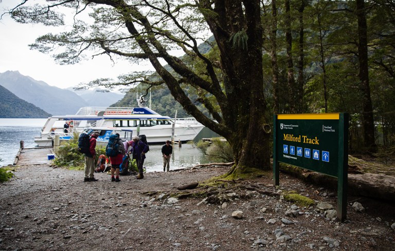
On a little jetty in the middle of nowhere a boat was waiting. A small group of people were making some final adjustments to their backpacks and walking the plank. Oh, sorry, jetty.
In this tiny place – Te Anau Downs – I was about to start one of the best walks in the world. And with no queues, barriers, signs, etc, it’s a modest start. Tickets in hand, I took my first steps towards wilderness. Across the other side of the lake it was dark and pouring with rain. Welcome to Fiordland, annual rainfall a LOT.

The boat ride was gorgeous, though I felt a strange mixture of excitement and slight trepidation; no houses, no roads, no people. One entrance, one exit – over 30 miles away.
Just over an hour later some other passengers and myself landed on an even tinier jetty surrounded by forests and mountains, right at the tip of Lake Te Anau. It’s here that the Milford Track properly begins, and the sandflies had gathered en mass to greet us.

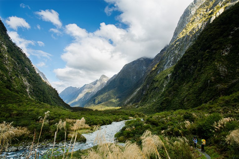
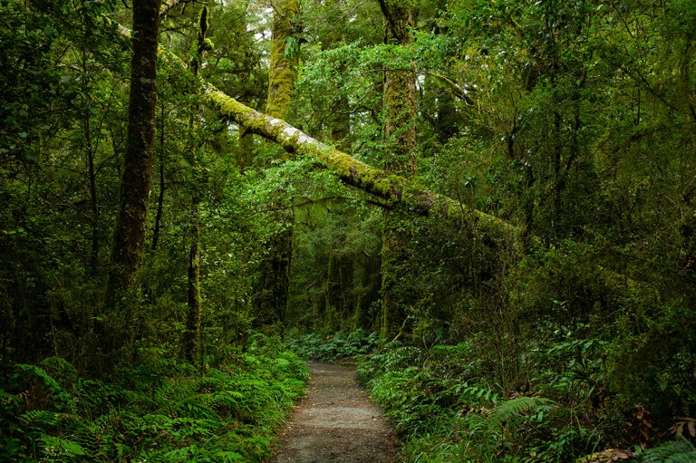
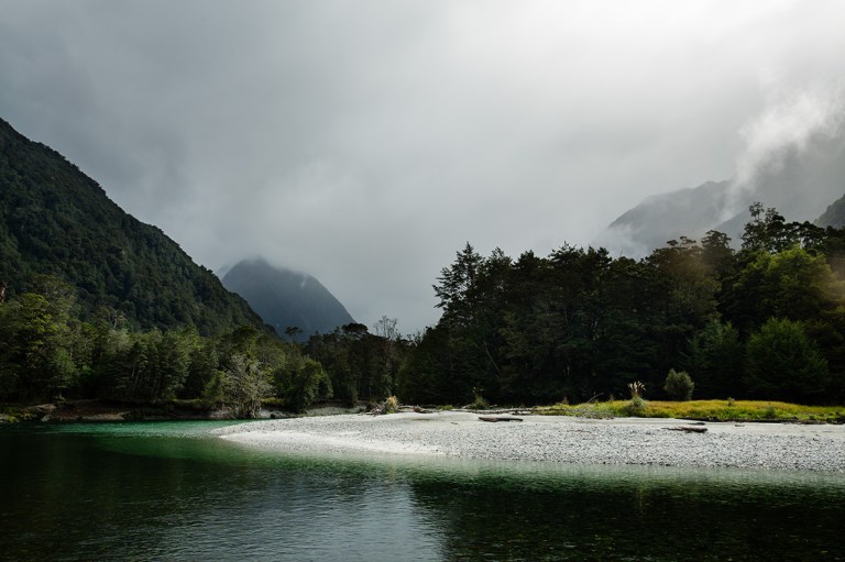
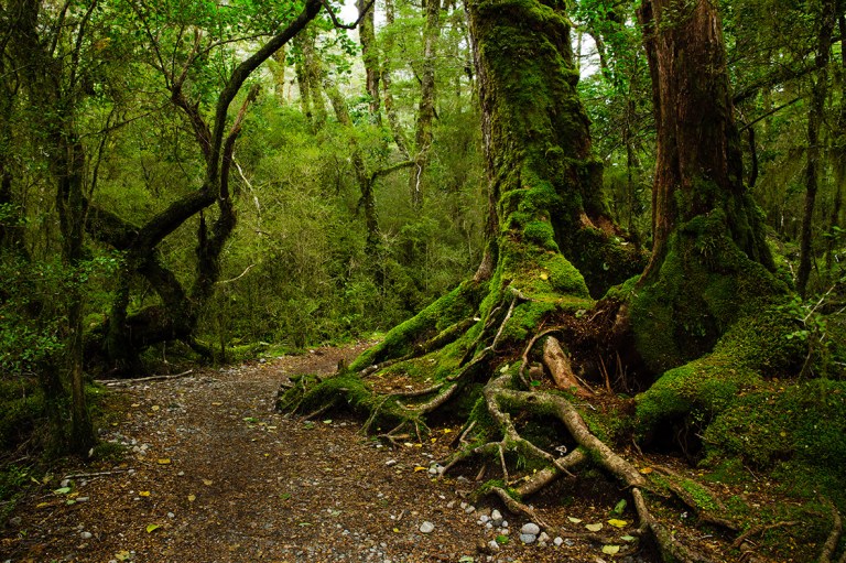
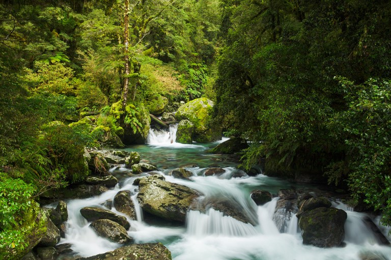
The first day’s walk is a gentle introduction; the path is wide and well-formed, and it’s only 3.1 miles (5km). Almost anyone could do it. You walk through the greenest forests you’ll ever see, following the side of the beautifully coloured Clinton River. It’s actually the least impressive part of the walk but at this point the novelty factor makes it pretty awesome.

It rained gently as I walked, and I was struck by how calm and quiet everything was (though before the Europeans came and introduced rodents and stoats the birdsong was apparently so loud you couldn’t hear yourself speak). I could really feel the weight of my bag pressing down on my shoulders already. Though I never weighed it I think my backpack was around 18kg, which is much heavier than average. This is because I had 9 days of food and my camera equipment – I was doing the Routeburn Track a day after this one! It made me worry about how I would feel after a full day of walking.
Then before I knew it, I was at the first hut and it was time for lunch. That was it – job done!
The format is simple when you get to a hut; go to a bunkroom, dump your stuff on a bed of choice, remember its number then write it down on a list found in the kitchen. The bunkrooms are basic – they have bunks and mattresses, and absolutely nothing else. Not even proper lights. There are a lot of sandflies in Clinton Hut, but don’t despair – it gets marginally better at the others.
In the coming hours more people started trickling in. By early evening the kitchen was bustling with people of all ages and nationalities, making impressive meals, playing games, chatting about what was ahead. There’s a lovely sense of community here, for whatever comes your way you’re all going to have to do it.
At 9:30pm the lights in the kitchen turned off. From then on it’s pitch black or torchlight. It pays to bring a powerful torch if you want to do anything skillfully!
I don’t think many people had a good night’s sleep this first night, myself included. It takes a little while getting used to sleeping around 20 or so other people on squeaky plastic mattresses. And of course someone snores. In fact several people will probably snore. I was so glad to have brought earplugs!
Milford Track Day 2: The difference an hour makes
Clinton Hut to Mintaro Hut (16.5km, 6hrs)

So 8:30am is late by tramping standards. Looking bleary-eyed at my phone’s clock (the only thing it’s good for here), I thought I was doing quite well. But when I finally plucked up the courage to lean up and look around I discovered that the bunk room was empty.
In the kitchen there were only a handful of people. It felt like I had missed something important here. I stuffed breakfast (pita bread with some vegetables and another with Nutella) and headed off.
Being last would become my trend for the rest of the hike; I’d become infamous for turning up at the next hut worryingly late. I was already slow as I’d stop and take photos every half an hour or so, let alone the fact that I’d start at least an hour later than average.
The day started as overcast, cold and drizzly – kind of what you’d expect for autumn in one of the world’s wettest places, I guess. The route continued to follow the river, where there are some beautiful stop off points. Staying still for more than a minute or two, though, attracted a hoard of sandflies.
At a little clearing that caught my eye for just how impossibly green it was, I felt a sharp pulse of air push past my head. And at the base of my feet was this little guy.
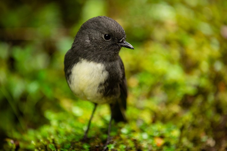
A bush robin, with absolutely no fear of people whatsoever. He looked up at me curiously, then flew onto my socks and pecked them. He’s not as striking as a lot of the other birds, but his personality won me over. Like a lot of native birds they’re fairly rare, but on the Milford Track they’re everywhere.
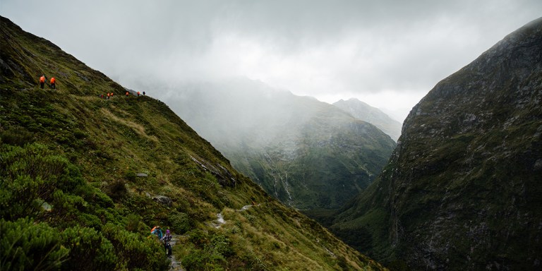
After a short while the track opens up and you enter into a large prairie area. This is where the really good stuff starts. Long grass and bushes begin to replace the dense green trees and all around you are those beautiful mountains. After a while you can see all the way down this part of the valley – which is where you’ll be walking for the rest of the day. It’s gorgeous. The rain will do a good job of hiding it away from you, though. As I arrived here the light drizzle turned heavier. Cue the waterproof trousers.
Thankfully it wasn’t long before I reached the shelter, which is roughly the halfway point. The heavens really opened at this point – lunchtime!
This spot also has some of the best views of the day’s walk. I’m sure they must have thought about that when they built the shelter. And what’s great is that you can take photos and stay dry. So I set up my camera, totally alone – some of the other hikers having just left as I arrived.
Just as I finished eating the clouds started to lift. Within another 15 minutes the world had opened up and it was stunning. I couldn’t believe that I had been oblivious to all this beauty whilst it had been raining. I took a LOT of photos.

From then on the day was perfect – blue skies and clouds tearing up around the mountain tops, waterfalls cascading down forests and metallic silver rock faces. I walked in awe for the rest of the day.
As you get further up the valley you reach the day’s most challenging part of the walk – Marlenes Creek. There used to be a bridge going across it but it has fallen down after a bout of particularly heavy weather. Now you’ve got to scramble over the rocks. On a dry day there’s little to worry about, but on days with heavy rain it becomes a whole lot more treacherous. Seeing all the huge branches and boulders wedged along the rocks of the riverbed was a strong reminder of its power. I heard that just the week before people weren’t able to pass it for days and had to be helicoptered out. Luckily for me I just got my feet a little wet.

From here you start to ascend, but on this day it’s never steep or particularly taxing, and it’s only for an hour or two. There are a few more rivers to cross and the views become possibly even more stunning (I couldn’t decide).

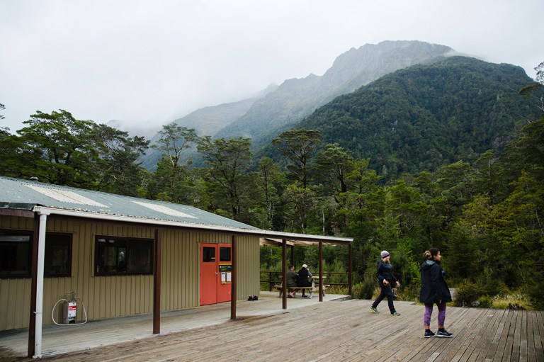
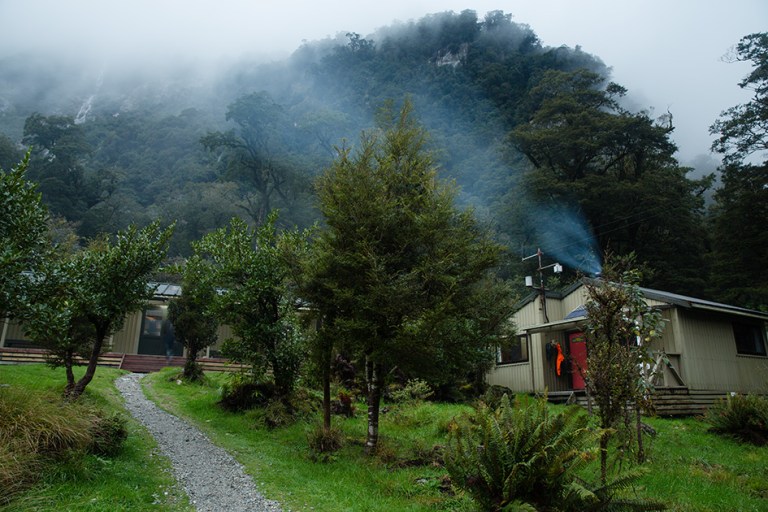
It’s not an awful lot longer until you reach the next hut – Mintaro. This is my favourite hut of the hike. It’s warm and cosy with a big open fire and nearby are some beautifully freezing swimming spots to ease those tired muscles in.
When I arrived at the hut I saw reams of sodden clothes hanging outside. All the people who had left several hours before me – and/or arrived several hours before me – had been absolutely drenched all day by the rain. They looked at my blue-skied photos in disbelief. There are two lessons to be learnt here: sometimes it does pay to be last, and also that the weather in Milford Sound can be totally different hour by hour, and mile by mile.
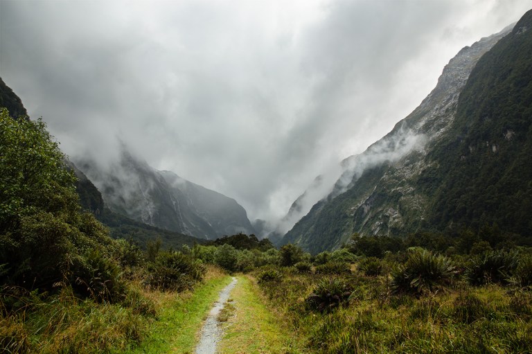
Milford Track Day 3: The edge of the world
Mintaro Hut to Dumpling Hut (14km, 7hrs)
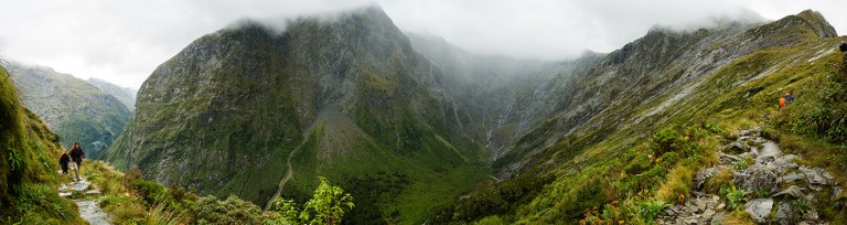
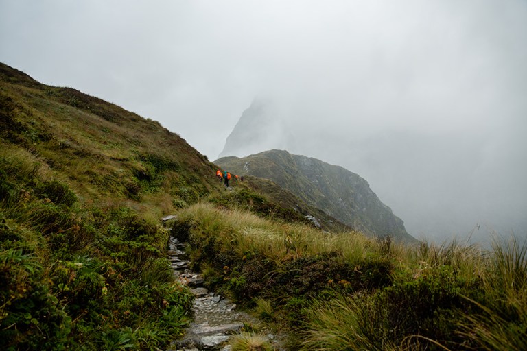
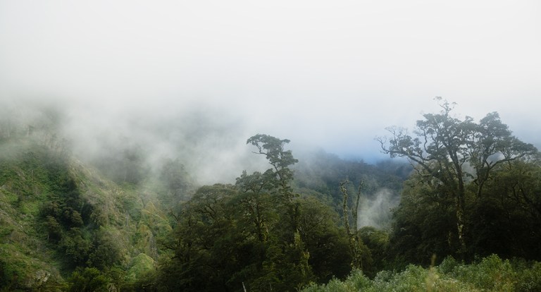
The top of Mackinnon Pass, Day 3 of New Zealand’s Milford Track, is probably one of the most beautiful views in the world. I say probably because I couldn’t really see it behind the clouds, buffeting wind and pin-sharp rain. It would clear for seconds, just enough for me to know that it was truly a world-class view, but not enough that I felt satisfied with it. I did what photographers do best; sit down, have a snack, and wait.
I had slept like a baby the night before – there’s nothing like a 10 mile hike carrying 18kg to send you to sleep, no matter how noisy or cold the conditions (I’d made the error of only having a summer sleeping bag, which didn’t cut it here. I had to wear essentially all my clothes to stay warm). I’d also made a concerted effort to get up somewhat earlier; this was the hardest day of the track with roughly a 500m ascent to the summit at Mackinnon Pass and then 1000m back down again. It’s 8.7 miles. I was still one of the last people to leave, though – everybody must have had the same idea.
The clouds had settled back over again with a light but steady rain and a cold bite in the air. It felt calm.

The uphill walk begins immediately, but the gradient is never crazily steep. It’s enough to get you all sweaty and out of breath though, even in cold rainy weather. Luckily the views back are the perfect excuse to stop.
It’s not too long before you reach the edge of the tree line. This is the only day of the Milford Track that takes you above it. From here you have endless views of mountains, forests and waterfalls in a huge bowl shape, and the only way past it is to go up.
With less shelter the wind started to increase in strength and the temperature took a drop. I was grateful for all the heat my body was kicking out now. The rain became heavier too, which meant it was time to put my camera in its top-of-the-range ziplock bag. The path started to get flatter, zigzagging sharply back on itself. The summit was undoubtedly close.
Soon after I crossed the top of the mountain and left yesterday’s valley behind me. Up here is incredible, elemental, and damn does it feel high.
It wasn’t long before all the warmth I had collected from going up evaporated whilst sitting at the top. I still only got fleeting glimpses of the world around me and the wind was so strong I felt like I could have been blown off the edge. Perhaps it was time to move on. And perhaps I would find a better viewpoint in the process, I justified to myself.
But it was a good decision, because from a little curve in the path I got this view:

It took about 20 minutes to get this shot. It involved putting a plastic poncho over me and my camera like an old Victorian photographer and holding fast. When a gap in the clouds came I’d lift it up from the camera and shoot madly before too much rain hit the lens. It took a number of attempts but I knew I had a winner with the last one. Satisfied that I’d got at least one good shot I carried on, my hands numb to the core and my camera drenched.
It was a very short walk to the Mackinnon Pass shelter. This basic shelter is a serious sight for sore eyes. It couldn’t be in a better place – either to save you from the elements just as you thought you would freeze, or just admire the views with a hot drink in hand.
I was so happy to see some of the other hikers when I entered – I hadn’t really seen any of them on the way up. We sat in the little room, sharing our disbelief at how awesomely horrible that bit of the hike was, our bodies steaming. No one had escaped the weather that day.
I waited a long time in there, hoping that the weather would change. But as I got colder and colder, and the rain simply continued, I knew that I would just have to carry on if I was going to get to the hut in time. Time to face the elements again.
For the first time in the hike I actually moved quickly. I was so cold I decided that jogging was a win-win situation – I could warm up and get down quicker. This part is the most difficult technically – it involves hopping across uneven rocks, though once again the gradient is never particularly steep and in the grand scheme of hikes it’s still pretty easy. But on this day, everything had turned to water – water running down the path, water dissecting it every several meters, water falling down all the rocks around you. I have never seen so much water. It was so much fun.

I loved jumping across all the little obstacles. For once, the weight of my backpack helped my momentum, and my boots had incredibly good grip. However, time and time again water crept over the tops of them and turned my feet to cold wet mush.
I got down the side of the mountain in less than an hour and reached the tree line again. The wind had gone entirely and the rain was very gentle. My boots squelched with every footstep. I was starting to make silly errors like tripping on rocks, and my legs felt weaker. As I looked at the time it made sense: it was almost 3pm and I hadn’t eaten lunch or scarcely anything since breakfast. Lessons to be learnt: don’t just eat when you’re hungry on a hike, and there is no sin in snacking like crazy.
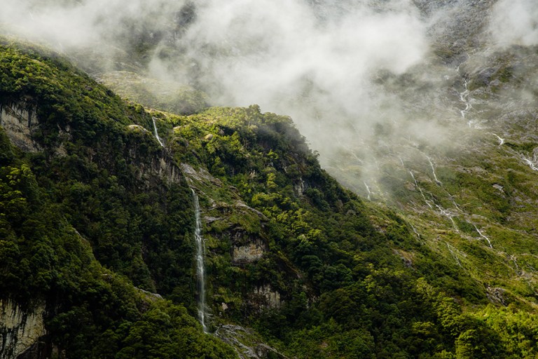
I made my way down past countless waterfalls and tributaries that roared through the lush green forests. They might have been the greenest I’d seen so far. But it felt like a lifetime walking through them before I reached Quintin Shelter, which is about three quarters of the way down the mountain, though I suspect it was my mind playing tricks on me.

The guided hikers stay in this spot and it’s stunning. I always thought that doing the Milford Track as a guided walk was a waste of money if you’re reasonably fit (it’s the same track, after all) but I was a little envious of this set up, and not least because I had another hour or two of walking ahead. There’s also a shelter that the independent walkers can use, and from here you can take a little 1-1.5 hour hike to Sutherland Falls.
At this point, especially after the washout day, I found it hard to muster up the motivation to hike further to see Sutherland Falls. But when would I ever do it again? Plus I could dump my backpack in the shelter whilst doing the walk. I ate a freeze dry meal for two (a thai curry made by Back Country Cuisine that was surprisingly nice), and went for it. It was 4pm almost, so I hurried up some.
Standing at the bottom of roaring Sutherland Falls is an exhilarating and drenching experience. On this day it was surrounded by even higher waterfalls that had been brought to life by the heavy rain. They would run dry soon after the rain stopped, though, leaving Sutherland Falls to take the title of the highest permanent waterfall in New Zealand.

With the amount of water that it throws out, it’s incredibly hard to get a clear shot of Sutherland Falls. But to my surprise mine came out pretty well. The reason for this was because the filter on my lens was so saturated with water that the spray wasn’t showing up on it any more. That’s never happened before or since. I love my Canon 5D3’s resilience.
Once back at the shelter it’s only 1.5 hours to the next and final hut of the track. The path is easy to walk, and the scenery isn’t as impressive or different compared to what’s just passed – it’s a good time to put your head down and go for it. It was starting to get dark as I was doing it, so I ignored the soreness of my wet feet and hurried up.
I can’t say I exactly enjoyed this part. It was steadily getting darker and I wasn’t sure of what I’d encounter ahead. And damn did my feet hurt. But that didn’t stop me from taking just a few very special photos. The clouds had started to part and golden light was pouring over them, it felt like I was walking through a dream or a fantasy landscape. Definitely worth setting up my tripod.


The path crossed a number of sandy riverbeds and everything around me was turning bluey-grey. I stepped up my pace and jogged. Luckily it wasn’t long before I saw a sharp outline among the trees. It was Dumpling Hut. I was so happy – though a more accurate description would be relieved.
I think the other hikers were as relieved as me when I finally arrived. The Milford Track has the unique ability of turning you and your fellow hikers into a big community. We had shared almost everything in these last three days and this gave us an awesome connection. I was sad to think that this was our last night around the fire together.
That night I decided to bring my mattress into the open fire area along with some of the other hikers. It looked so warm and inviting compared to the bunkroom. I laid down stiffly below all the wet clothes that had been laid out everywhere. I wanted to use this time to reflect on just how epic the day had been, but the rest of me had other ideas – I fell asleep instantly.
Milford Track Day 4: Going the distance
Dumpling Hut to Sandfly Point (18km, 6hrs)
Sleep is probably the swiftest road to recovery for a hiker, but on my last day of the Milford Track this wasn’t enough. Having slept in the common room by the fire I’d been woken early by all those enviable early-risers, and getting up some 20 minutes later was a chore. My legs were stiff and my feet were tender. I hobbled around collecting my belongings, packing them for the last time.
Spirits were running a little lower this morning as people gathered their damp clothes and soggy boots from around the hut. My boots were cold and wet to the core – wearing them was not going to be pleasant. Yesterday’s rain had definitely left its mark. On the plus side I’d eaten enough of my food supplies that packing had become easier and I could feel a difference in the weight of my bag.
There was a boat to catch at the end of this day, so I felt a little more pressure to be fast. I also had the greatest distance to cover (11.2 miles), but it was pretty much flat the whole way. I ate my customary Nutella and pita bread for breakfast and set off fairly early.

My feet were in an incredible amount of pain from the word go. I’d owned my hiking boots for 5 years and walked miles upon miles in them, and during this time only ever developed one blister on the ball of my foot (a symptom of long distance walking as opposed to anything else). But walking for one day whilst they were wet had given me blisters and soreness all over, and especially on the edges of my toes. Wet feet is an absolute killer when hiking. Then the several hours of jogging and hopping down rocks the day before had tired my legs out too. I was a bit of a mess, basically.
With all of this in mind I decided to powerwalk my way through the day for as long as I could. I put on a loud and energetic playlist.
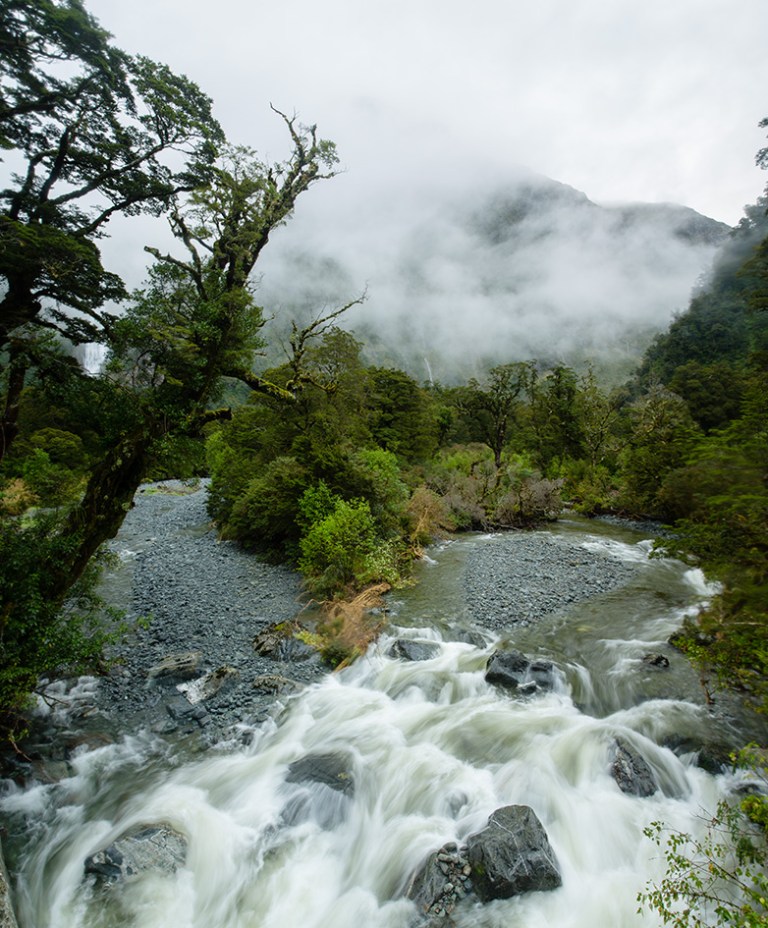
It was the first sunny morning of the hike, with the temperature already climbing. It was magical. The path was indeed very flat and quite wide in a lot of areas, following the Arthur River. This river would lead us all the way to our final destination: Milford Sound.

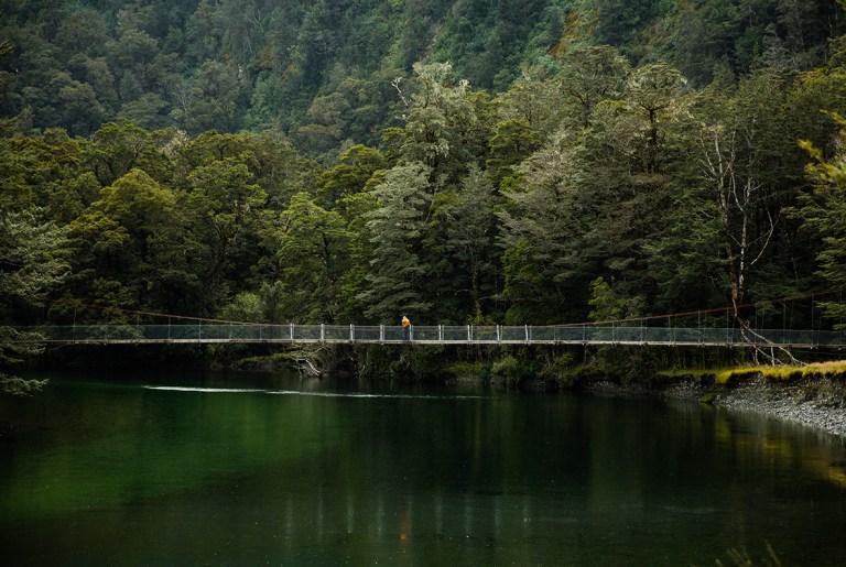
Apart from several awesome suspension bridges that give some beautiful sweeping views down the valley, the path is hemmed in by thick green forests for most of the time. It’s once again an easy spot to put your head down and make good ground. I found myself tearing past the first several mile markers.

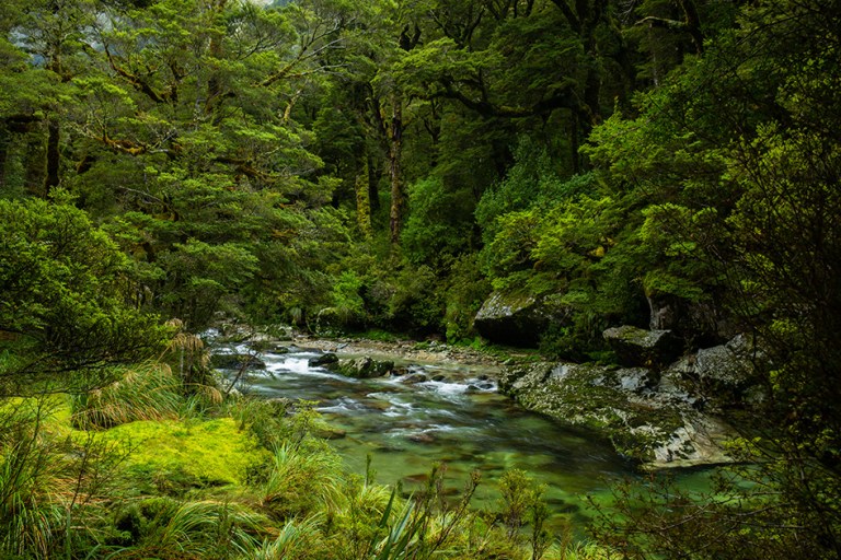
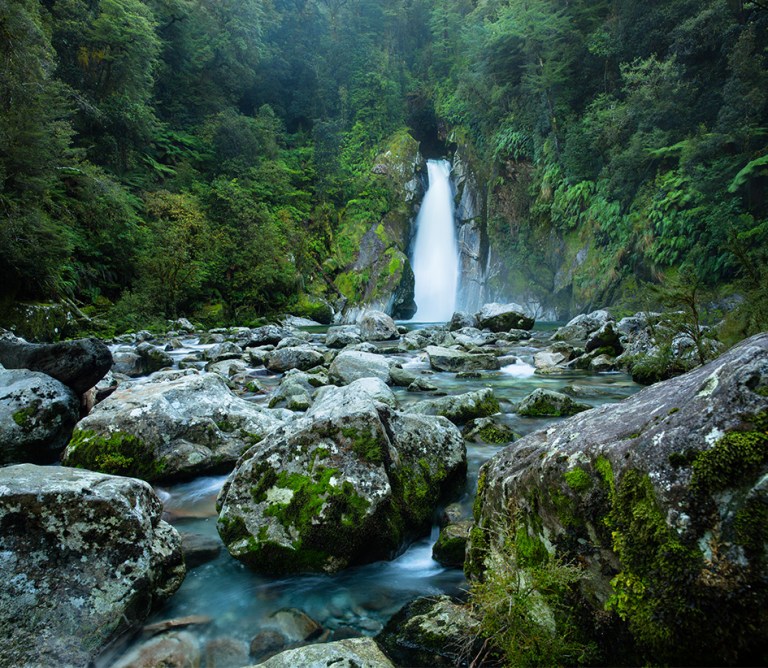
After an hour or so I reached what became my favourite waterfall of the hike: Mackay Falls, a minute’s detour off the main track. It’s nowhere near as large as Sutherland Falls but tucked away in a lush green corner with bright turquoise water it’s incredibly beautiful. And it still kicks out a whole lot of cold spray for good measure.

I spent quite some time there just admiring it and trying to take a photo without getting water on my lens (fail). Unfortunately when I set off again it meant that my adrenaline levels had dropped enough that I could feel the pain in my feet. It took a while to walk through the pain again.
The river grew wider and moved slower and there was scarcely a cloud in the sky. I couldn’t help but feel a little envious of the people hiking a day behind me who were heading to the summit, though I was incredibly grateful to not have to walk in rain again.
There were a number of gorgeous views across the river, but I did not stop frequently or long to look at them on this day. It didn’t take too long to reach the halfway point, but physcially it felt like I’d been walking for a long time. For the first time I paid a lot of attention to the mile markers – probably a sign that I was keen to finish.
The end is near!
By the time you reach Giant Gate Falls, another gorgeous spot, you can start to relax; the end of the Milford Track isn’t so far from here – about 1.5 hours. This waterfall is particularly striking because you get to look at it from a suspension bridge that crosses the river it cascades into. It’s also a good spot to have lunch and a paddle. There’s a shelter a short distance before it, too.
By this point I knew I’d reach the end in good time, and with that knowledge my energy ebbed away; my power walk became a rather leisurely hobble. My feet had become too sore to ignore, too. Fortunately the path had become even flatter and wider – it felt more like a walk in a park, ironically.
I couldn’t stop thinking about when I’d see the next marker as I walked through the endless forests. They were beautiful, but I wasn’t so enthralled by them. Pehaps it was because I’d been spoilt by yesterday’s views, perhaps it was because I was in too much discomfort. I’d walk to the beat of the music to forget about my feet and keep my pace up. I started to measure distance by songs, too; I’d keep track of how many I had listened to and add their approximate lengths together. From that I’d figure out roughly how many miles I’d just walked. Yep, things were getting desperate.
I knew the hike was 33-something miles long, and when I saw the 33 mile marker I screamed for joy. It really wasn’t long to go now. I took a photo to commemorate this moment; not a good photo by any means, it was hazy from all the moisture in my lens/camera and from the grease on the filter I could only seem to spread around. But perhaps it was the most accurate photo; a modest little marker shining out from all the hazy undefined green.

I was preparing for another 20 minutes walk or so from this point, but in the space of one song or so I spotted a little hut poking out from the trees. Was that it? Was this the end? I withheld my excitement just to make sure.
It was. ‘Welcome to Sandfly Point’ it said. They weren’t lying about the sandflies.
The place was empty, which felt a little strange. But as I looked through the window I saw one of my hiking buddies who had been waiting for me. Like me he was the last to get up and the last to leave. Unlike me he was incredibly fit and very fast, and always finished hours ahead of me. I didn’t think I’d see him again, I was so happy! We gave each other a smelly I-haven’t-washed-or-showered-for-days celebratory hug.

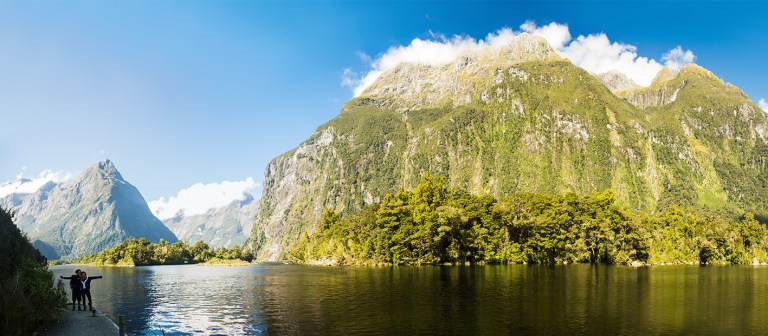
We walked to the edge of the jetty, which had undoubtedly the best view of the day; the Milford Sound.
A number of triumphant photos had to be taken, of course.
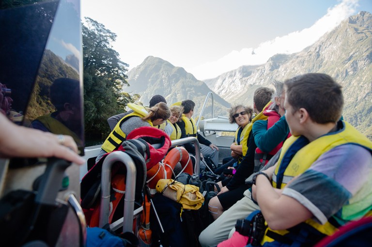
A short while later a little speedboat pulled up beside the jetty. It was nowhere near as formal as I’d expected; it basically just made the short journey across the mouth of the river whenever there were enough people to carry. Soon after the Australian family arrived. These were the first guys I had met on the Milford Track, four days ago on that first jetty on Lake Te Anau. This lovely family had given me all sorts of food and support along the way, including a woolly hat at the summit, and I was once again elated to see them. It felt a little like a family reunion.
We got on that boat and it jetted us across the river. The sun was beating down and I was in disbelief at everything that had happened. I had booked the hike over 6 months ago and now it was over. In a short while we were on the other side, back in a little pocket of beautiful civilisation called Milford Sound.
I was sad to leave my hiking buddies. The beauty and challenges of the Milford Track had given us a special connection that I hadn’t experienced anywhere else. I waved goodbye and headed off to the hostel – the final humble steps of my adventure.
Want to know more about the Milford Track? Check out these other posts:
How difficult is the Milford Track? The good, the bad, the ugly
Milford Track packing list: Food, Clothes, and everything else

Absolutely stunning! But is it difficult to hike around there?
I think there are some hard hikes around, but this particular one is really straight forward! Just quite long…
Absolutely stunning! I had some great hiking in Australia NT too, but your view is even better!
Thank you! The view was absolutely amazing, even in the pouring rain and wind :)
Thanks for posting the photos, they must be the most beautiful I have ever seen. Certainly inspiring me. And also your comments will have me checking my wet weather gear very closely! And thanks for the list of items and hints for the Mildord. We are doing it in 3 weeks time.
Ciao
Peter
Hi Peter, thanks so much! The Milford Track is so beautiful, I’m sure you will love it. And yes, the chances of it raining are very high so that’s a wise idea!! Fingers crossed it’s not the wash out at the top like it was for me!! Best of luck :)
Such beautiful pictures, especially those of the waterfalls on day 4! Which camera do you have and do you know the settings of those pictures? :)
Thank you! I used a Canon 5D3 at the time with a 24-70mm lens. The waterfall shots have a shutter speed of around 2 seconds, aperture f14-16 :)